
Can You Fly a Perfect VFR Circuit at Sedona? X-Plane 12?
SEO Title: Airport Challenge: Can You Fly a Perfect VFR Circuit at Sedona? | X-Plane 12
Meta Description: Think your VFR circuit skills are good? Try the Sedona Airport challenge in X-Plane 12. Master the traffic pattern, altitude, turns and approach on a 500-foot mesa.
Primary SEO Keyword: Sedona Airport X-Plane 12
Secondary Keywords:
- KSEZ X-Plane 12
- Sedona Airport challenge
- X-Plane 12 VFR challenge
- X-Plane 12 circuit challenge
- Sedona Airport landing
- Sedona Airport VFR
- KSEZ VFR circuit
- X-Plane 12 landing challenge
- VFR traffic pattern challenge
- X-Plane 12 Cessna 172
- Sedona Airport runway 03
- Sedona Airport runway 21
- VFR circuit training
- flight simulator challenges
- learn VFR flying
Suggested URL Slug:/airport-challenge-sedona-x-plane-12-vfr-circuit/
Airport Challenge: Can You Fly a Perfect Circuit at Sedona?
Think your VFR circuit is getting pretty good?
You know how to fly downwind.
You know when to turn base.
You’ve learned to judge your approach.
You know what a stable final should look like.
You know when to go around.
Good.
Now let’s put those skills to the test.
Because this time, we’re not going to give you an easy airport with a huge runway, flat terrain and plenty of room to make mistakes.
We’re heading to one of the most spectacular airports in the United States.
We’re going to Sedona Airport — KSEZ.
And we’re going to fly a circuit.
Not a sightseeing flight.
Not a GPS adventure.
Not a straight-in approach.
A proper VFR traffic-pattern challenge.
And there’s a reason I’ve chosen Sedona.
The airport sits on top of a mesa roughly 500 feet above the surrounding area, creating a spectacular but challenging environment. The FAA itself notes that pilots can encounter windshear, turbulence and updrafts/downdrafts near the mesa edge.
In other words:
This is where your circuit skills matter.
Welcome to Sedona
Sedona Airport is located approximately two miles southwest of Sedona, Arizona.
The airport sits at approximately 4,830 feet MSL, with Runway 03/21 measuring 5,132 feet long and 100 feet wide. It is an uncontrolled airport using CTAF/UNICOM 123.0.
And then there’s the part that makes this airport special.
The airport is sitting on a mesa.
From the air, the surrounding red-rock landscape is spectacular.
But don’t let the scenery distract you.
You’re here to fly.
Why Sedona?
You might be wondering:
“Why choose Sedona for a circuit challenge?”
Because it combines several things we’re trying to learn throughout this VFR series.
Visual flying
You need to look outside.
Circuit geometry
You need to understand where you are relative to the runway.
Altitude awareness
The airport is already sitting at a high elevation.
Approach judgement
The surrounding terrain makes the visual picture particularly important.
Wind awareness
The published airport information specifically warns about turbulence, windshear and vertical air movements near the mesa edge.
Decision making
You need to recognise when the approach isn’t working.
And perhaps most importantly:
You can’t simply rely on numbers.
You need to fly the picture.
That’s exactly what we’ve been building toward.
Your Aircraft
For this challenge, I’d recommend something simple.
Cessna 172
Why?
Because this isn’t an aircraft-performance challenge.
We’re testing your VFR flying skills.
The C172 gives you:
- Predictable handling
- Good visibility
- Straightforward systems
- Familiar performance
- A good platform for practising circuits
You can use another light single if you prefer, but for consistency, I’d suggest everyone attempting the challenge uses a C172.
Before You Even Start
Don’t load into X-Plane 12 and immediately start the engine.
This is part of the challenge.
Before you move, find out where you are.
Look at:
- Airport layout
- Runway
- Taxiways
- Surrounding terrain
- Wind
- Active runway
- Traffic pattern
- Published information
This is exactly the habit we’ve been trying to develop.
Plan before you move.
Know Your Airport
The current FAA airport information lists:
Airport: Sedona Airport
ICAO: KSEZ
Elevation: approximately 4,830 ft MSL
Runway: 03/21
Length: 5,132 ft
Width: 100 ft
Surface: Asphalt
CTAF/UNICOM: 123.0
AWOS: 118.525
The published propeller-aircraft traffic-pattern altitude is:
6,004 ft MSL
That’s approximately:
1,173 ft AGL
That number is important.
But don’t just memorise it.
Understand why we’re using it.
We’re building a traffic pattern around the airport’s published information rather than simply applying a generic 1,000-foot pattern altitude.
Which Runway?
This is where things get interesting.
Sedona’s current published information identifies:
Runway 03
As the calm-wind runway for landing.
Runway 21
As the preferred runway for takeoff.
The FAA Chart Supplement also notes that Runway 03 has an uphill slope, while the published airport information includes specific considerations for Runway 21 operations and strong southwest winds.
So don’t simply decide:
“The runway number looks convenient.”
Check the current conditions.
For this challenge, however, we’re going to establish a specific training scenario so that everyone is attempting the same circuit.
The Challenge Scenario
For the standard LetsFlyVFR challenge:
Aircraft
Cessna 172
Airport
KSEZ — Sedona
Conditions
Daytime VFR
Weather
Light winds
Runway
Runway 03
Traffic
VFR circuit
Objective
Fly a complete, stable traffic pattern and land within the intended touchdown area.
But there’s a catch.
You’re Not Allowed to Fly a Straight-In
That’s right.
No GPS direct-to.
No straight-in approach.
No five-mile final.
No cheating the circuit.
You’re going to fly the pattern.
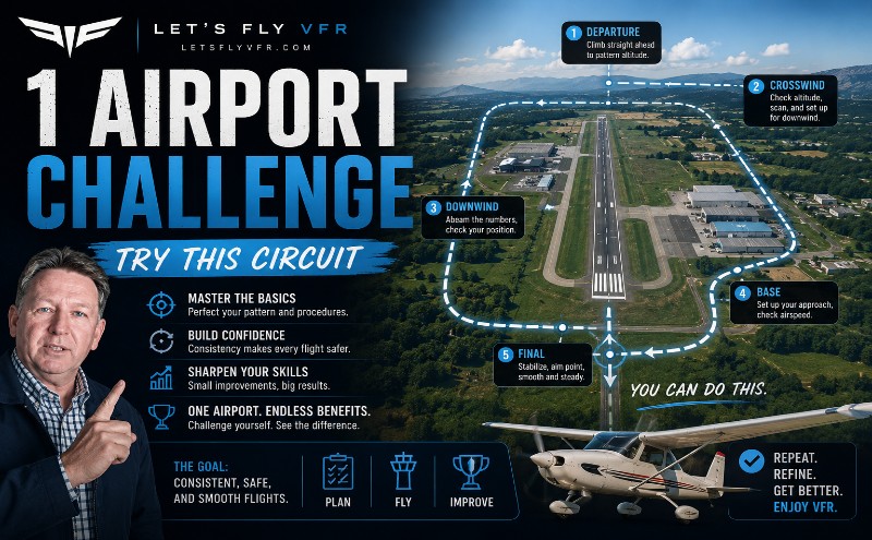
Departure → Crosswind → Downwind → Base → Final → Landing
Why?
Because we’re testing the skill we’ve been building throughout this series.
Challenge Rule #1 — Fly the Pattern
The FAA’s standard traffic-pattern guidance recommends a structured pattern, with propeller aircraft normally entering at the published or applicable pattern altitude and maintaining predictable pattern geometry. Unless otherwise indicated, turns are normally to the left.
For this challenge, we’re looking for:
A predictable circuit.
Not a huge circuit.
Not a tiny circuit.
Not a circuit that changes shape every time.
Predictable.
Challenge Rule #2 — No GPS for the Circuit
You can use the GPS to understand where the airport is before the flight.
But once you’re established in the circuit:
Fly visually.
Look outside.
Use:
- Runway
- Terrain
- Horizon
- Airport layout
- Visual references
This is a VFR challenge.
We’re testing your ability to fly the aircraft—not your ability to follow a magenta line.
Challenge Rule #3 — Know Your Altitude
Your target traffic-pattern altitude is:
6,004 ft MSL
for propeller aircraft under the published airport information.
But here’s the important part.
Don’t become obsessed with holding exactly one number.
You should be near the published pattern altitude and maintaining a stable pattern.
Watch:
- Terrain
- Aircraft attitude
- Altitude
- Airspeed
- Position relative to the runway
And keep the circuit predictable.
Challenge Rule #4 — Don’t Fly the Pattern by Stopwatch
This is important.
Don’t decide:
“I’ll fly downwind for exactly 30 seconds.”
Instead:
Look outside.
Judge your position.
Where is the runway?
Where is the approach end?
Where are you relative to the runway?
When will the 45° base-turn position occur?
This is the skill we’ve been developing in our previous lessons.
Your Downwind Challenge
Once established downwind, you should be able to look at the runway and understand your position.
The runway should be:
Parallel to you.
You should know:
Where you are.
You should know:
Where you’re going.
And you should be thinking ahead.
Don’t wait until you’re abeam the approach end and suddenly think:
“Oh… I need to turn base.”
The 45° Cue
One of the visual cues we’ve already discussed is the runway’s relationship to your aircraft.
When the approach end of the runway reaches an appropriate visual position—roughly 45° behind the wing—you should be thinking about the base turn.
The exact point will vary with:
- Aircraft
- Wind
- Airspeed
- Pattern size
- Terrain
- Local procedures
So don’t treat 45° as a magical trigger.
Treat it as a visual reference.
The Sedona Problem
Now we add the challenge.
Sedona isn’t just a runway sitting in the middle of a flat field.
You’re on a mesa.
The surrounding terrain can affect your visual references.
The airport’s published information warns of:
Windshear
Turbulence
Updrafts
Downdrafts
particularly around the mesa edge.
That means you need to be ready for the aircraft to behave slightly differently from the perfectly calm-air circuit you may be accustomed to.
Don’t Chase the Aircraft
This is where your previous lessons come back.
If the aircraft suddenly rises slightly:
Don’t immediately make a huge pitch correction.
If it sinks:
Don’t yank the aircraft back toward the pattern altitude.
If you encounter a little turbulence:
Fly the aircraft.
Make appropriate corrections.
Maintain control.
Allow the aircraft to settle.
Don’t chase every little movement.
Turning Base
This is one of the most important parts of the challenge.
A good base turn should place you in a position where you can establish a stable final.
A bad base turn creates problems that you then have to solve on final.
If you turn too early:
You may find yourself too close to the runway.
If you turn too late:
You may find yourself too far away.
If you overshoot:
You may have to make an aggressive correction.
And that brings us to one of our key rules:
Don’t Force the Base-to-Final Turn
If you overshoot final:
Don’t yank the aircraft around.
Don’t make a steep, aggressive turn simply because you want to get back onto the centreline.
If the geometry isn’t working:
Go around.
There is no prize for forcing an ugly approach onto the runway.
The FAA’s standard traffic-pattern guidance specifically warns against overshooting final and continuing onto a track that penetrates the final approach area of another runway where applicable.
The broader lesson is simple:
Good pilots recognise when geometry has gone wrong.
Final Approach
Now comes the part we’ve already practised.
Look outside.
Find:
Runway.
Centreline.
Aiming point.
Horizon.
Now ask:
“Does this approach look right?”
Don’t immediately stare at the instruments.
Look at the runway.
What Are You Looking For?
A stable final should look:
Predictable.
Your runway alignment should be good.
Your speed should be appropriate.
Your configuration should be correct.
Your aiming point should be stable.
Your corrections should be small.
And your workload should be reducing—not increasing.
If you’re getting busier and busier as you approach the runway:
Something probably needs fixing.
The Sedona Visual Challenge
Here’s the part I really want you to practise.
On final, temporarily stop looking at the instruments.
Look outside.
Can you identify:
Too High?
Does the runway perspective look wrong?
Too Low?
Does the aiming point move in a way that tells you your flight path isn’t right?
Too Fast?
Does the aircraft appear to be carrying excessive energy?
Too Slow?
Does the aircraft feel like it’s approaching the edge of its comfortable energy state?
Misaligned?
Is the centreline moving away from you?
This is what we’ve been training for.
The Mesa Edge
As you approach the runway, remember that you’re not approaching an ordinary flat airport.
You’re operating on top of a mesa.
That makes the visual environment different.
The airport’s elevation is approximately 4,830 feet MSL, and the runway itself varies in elevation between its two ends.
High-elevation operations also mean you should be thinking about aircraft performance differently than you would at sea level.
This is another reason why the C172 is a good training aircraft for the exercise.
Your Touchdown Challenge
We’re not looking for:
“Did you touch the runway?”
That’s too easy.
We’re looking for:
Where did you touch down?
Ideally, you should have a predetermined touchdown area.
Don’t aim at the very beginning of the runway.
Don’t aim halfway down the runway.
Pick an appropriate aiming point and fly the approach toward it.
Then let the flare and landing happen naturally.
The Scoring System
Let’s make this a proper challenge.
Give yourself a score out of 10.
1 Point — Preflight Planning
Did you correctly identify:
- Runway
- Wind
- Pattern altitude
- Traffic pattern
- Airport information?
1 Point — Radio
Did you make appropriate CTAF calls?
1 Point — Pattern Altitude
Did you maintain the published pattern altitude reasonably well?
1 Point — Downwind
Was your downwind predictable and properly positioned?
1 Point — Base Turn
Did you turn base at an appropriate visual position?
1 Point — Final Alignment
Did you establish final without excessive correction?
1 Point — Approach
Was your approach stable?
1 Point — Visual Judgement
Did you actually use the runway and visual references?
1 Point — Landing
Did you touch down within your intended touchdown area?
1 Point — Decision Making
If the approach became unstable, did you go around?
10/10 Isn’t the Real Objective
Here’s the important bit.
Don’t become obsessed with the score.
If you get:
6/10
that’s useful.
You now know what needs work.
If you get:
7/10
excellent.
Identify the three areas that need improvement.
If you get:
9/10
great.
But can you repeat it?
That’s the real test.
The Repeatability Test
Fly the challenge three times.
Don’t change the weather.
Don’t change the aircraft.
Don’t change the runway.
Don’t change the airport.
Now compare your three circuits.
Circuit 1
What went wrong?
Circuit 2
Did you fix it?
Circuit 3
Can you repeat the improvement?
That’s how you turn a challenge into training.
Advanced Challenge
Think you’re getting good?
Let’s make it harder.
Fly the same challenge with:
A Crosswind
Now you need to manage:
- Ground track
- Crab angle
- Wind correction
- Centreline
A Different Aircraft
Try a Piper Cherokee.
Or another light single.
Now your sight picture and handling will change.
No GPS
Fly entirely visually.
No Autopilot
Obviously.
No Instrument Fixation
Use the outside world.
Go-Around
On one circuit, deliberately abandon the approach and execute a go-around.
The objective isn’t simply landing.
It’s demonstrating that you can recognise and manage a poor approach.
Expert Challenge: Three Consecutive Good Circuits
Here’s the ultimate version.
You don’t pass this challenge by producing one beautiful landing.
You need:
Three consecutive circuits.
All three must have:
- Sensible pattern geometry
- Appropriate altitude
- Controlled airspeed
- Good base turn
- Stable final
- Correct runway alignment
- Appropriate touchdown
- No unnecessary corrections
And if one approach becomes unstable?
Go around.
Then start again.
That’s a much better measure of skill than one lucky landing.
What This Challenge Is Really Testing
At first glance, this looks like a landing challenge.
It isn’t.
We’re actually testing:
Planning
↓
Situational awareness
↓
Pattern geometry
↓
Visual judgement
↓
Aircraft control
↓
Energy management
↓
Decision making
↓
Landing
That’s why I like Sedona for this challenge.
The airport makes you think.
And that’s exactly what we want.
Don’t Let the Scenery Fool You
Sedona is spectacular.
The red rocks.
The mountains.
The mesa.
The views.
It is one of the most visually impressive airports you can visit in a flight simulator.
But once you’re in the circuit:
Forget the scenery.
You’re flying.
Your job is to:
Maintain the pattern.
Maintain control.
Maintain awareness.
Fly the approach.
Land safely.
The scenery can wait.
Your Final Challenge
Here’s what I want you to do.
Open X-Plane 12.
Load:
Cessna 172
At:
KSEZ — Sedona
Set up a daytime VFR environment with light winds.
Before moving:
Check the airport information.
Check the wind.
Check the runway.
Check the pattern altitude.
Then:
Fly one complete circuit.
Don’t rush.
Don’t chase numbers.
Don’t use the GPS to fly the pattern.
Look outside.
Fly the geometry.
Judge the approach.
And land.
Then do it again.
And Here’s the Catch…
On your second circuit, you’re not allowed to repeat the first circuit’s biggest mistake.
If you turned base too late:
Fix it.
If you were too fast:
Fix it.
If you were too high:
Fix it.
If you overshot final:
Fix it.
If you were constantly looking inside:
Look outside.
That’s how we’re going to build your skills.
One mistake at a time.
Can You Fly the Sedona Circuit?
That’s the challenge.
Not:
“Can you land at Sedona?”
But:
“Can you fly a predictable, stable VFR circuit at Sedona?”
There’s a big difference.
Anyone can eventually get an aircraft onto a runway.
The skill we’re trying to build is being able to plan the circuit, anticipate the next phase of flight, recognise problems early and make small corrections before those problems become big ones.
That’s what good VFR flying looks like.
Your Score
After your flight, leave yourself a score:
__/10
And write down your one biggest mistake.
Not ten.
Just one.
Then fly it again.
Try to eliminate that mistake.
Once you’ve fixed it, find the next one.
That’s how you improve.
The LetsFlyVFR Challenge
We’re going to be doing more of these.
Because learning to fly shouldn’t always feel like studying a textbook.
Sometimes you need a challenge.
Sometimes you need a difficult airport.
Sometimes you need to test yourself.
And sometimes you need to discover:
“I thought I was better at this than I actually am.”
That’s not failure.
That’s useful information.
Because now you know what to practise.
What’s Next?
We’ve now taken our VFR training from:
Startup
→ Taxi
→ Radio
→ Run-Up
→ Runway
→ Approach Judgement
→ Common VFR Mistakes
→ Visual Landing Skills
→ Airport Challenge
And the next logical step is to go deeper into the thing that makes or breaks almost every VFR landing:
The Traffic Circuit
We’re going to break down:
Downwind
Base
Final
The Base Turn
Pattern Spacing
Aiming Point
Altitude
Airspeed
Power
Configuration
And most importantly:
How do you know when to turn?
Because once you can consistently fly the circuit, your landings become dramatically easier.
A Note About Real-World Flying
This challenge is designed for X-Plane 12 and is intended as simulator-based training.
Sedona Airport is a real airport with published operating information, traffic-pattern procedures, noise-abatement considerations and terrain-related hazards. Conditions, runway use and airport procedures can change.
For real-world operations, pilots should always consult current NOTAMs, the current Chart Supplement, weather information and applicable airport procedures, and follow the guidance of a qualified flight instructor.
The current FAA information identifies KSEZ as an uncontrolled airport, publishes CTAF/UNICOM 123.0, a propeller-aircraft pattern altitude of 6,004 ft MSL, and specific runway/wind considerations.
This is a simulator challenge. In the real aircraft, fly the published procedures and get proper instruction.
Ready?
KSEZ.
Cessna 172.
Runway 03.
Three circuits.
One goal: Fly the pattern properly.
Can you score 10/10?
Let’s find out.
Learn the picture. Fly the pattern. Make the decision. Become a better virtual pilot.


Leave a Reply